|
|
|

The Green River (Desolation /Gray Canyons)
The Green River is one of the major riverways in the Western United States. Beginning in the mountains of west-central Wyoming, the Green flows south, first through a tiny portion of northwest Colorado and then Utah. The river is stilled in the huge reservoir behind Flaming Gorge Dam, completed in 1964. From there, the Green carves a fantastic course through several deep and picturesque canyons, on its way to the confluence with the Colorado River deep in Canyonlands National Park. Although a longer river to the point of confluence than the Colorado, the Green surrenders it name and contributes to the mighty Colorado River that thunders through Cataract Canyon and, after Lake Powell, the Grand Canyon.
Desolation and Gray canyons is an 86 mile trip through some of the most remote country in the United States, through northeastern Utah. It was first described and mapped by John Wesley Powell in his 1869 and 1871 expeditions, and many of the rapids and canyon formations still carry the names given them by Powell and his party. At its deepest point, Desolation Canyon is deeper than the Grand Canyon (over 5,600' from canyon floor to the top of the plateau)...but the run itself is generally fairly easy. The first 26 miles are flat, slow moving water -- after that, Class 2 rapids spring to life and appear every mile or mile and a half. The toughest spots are probably Three Fords Rapid (which nearly drowned one of Powell's men in 1869) and Coal Creek Rapid, which is extremely rocky at low and mid flows, and features some huge waves and holes at high flows. Both warrant a solid Class 3 rating at moderate flows.
Desolation and Gray canyon (affectionately known as Deso) is one of our favorite spots on the planet. We've run Deso six times together (1992, 1996, '97, twice in '98 and '99), and although the whitewater is mostly tame, the scenery and solitude are unmatched by anyplace else we've been on the river.
The river is managed by the Bureau of Land Management in Price, Utah, and a permit is required to run the river all year.
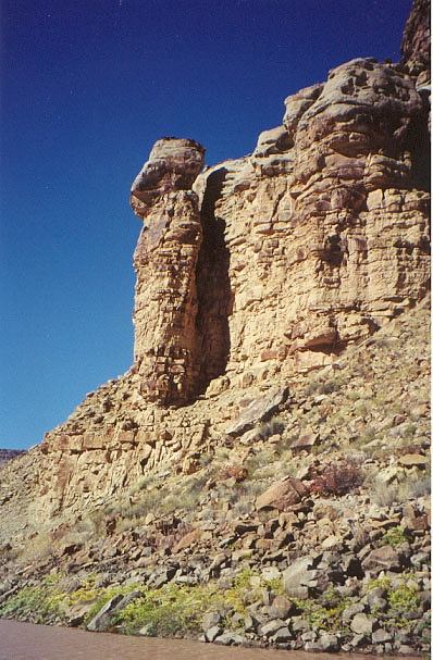
Queen Nefertitti, one of the most remarkable rock formation on the run. Powell named this after the fabled Egyptian Queen, and it is located about 8 miles from the take-out point. October 1998
Next Desolation photo....
Back to our outdoor index...
Back to dave and karin's home page....